With time, Lakhi’s age caught up with her, and she showed signs of slowing down, old injuries got inflamed and she seemed to prefer resting against the mud beds in her enclosure
With time, Lakhi’s age caught up with her, and she showed signs of slowing down, old injuries got inflamed and she seemed to prefer resting against the mud beds in her enclosure. Late Saturday evening on the 3rd of March, she seemed more weary than usual, and even as her knees buckled under her, Asha and Coco rushed to her side to support her. Asha appeared calm and strong, as if she knew in her own way that this was it – Coco panicked initially, rushing about and running circles around her fallen friend. The team rushed in, the crane was called in to lift her back to her feet and support her – the elephants moved aside and watched, Asha touching them gently as they huddled together. They stood back as the team tried to get her back to her feet, even the younger elephants seemed uncharacteristically calm. Maybe they knew, maybe they realised it was time to let go and had their chance to say their goodbyes, and wanted to let her pass in peace. Lakhi resisted being lifted, as if she too knew her time had come. She let out her final breath and slumped down against the mud bed, eyes shut looking like she was completely at peace. As the team moved away, heartbroken, Asha rumbled loudly from where she was standing, but none of the elephants moved – Coco let out a small wail, and from every enclosure elephants responded softly with rumbles, trumpets and huffs all the way from the bulls to the closerby females like Phoolkali like an orchestra of calm, reassuring solidarity for their fallen friend.
Username: All_the_Best Published on 2024-12-24 11:53:18 ID NUMBER: 127760
Cardi B - Imaginary Playerz
Stream/Download: https://CardiB.lnk.to/ImaginaryPlayerz

My new album AM I THE DRAMA? is out September 19th. Pre-order now: https://cardib.lnk.to/AITD

Subscribe for more official content from Cardi B: https://CardiB.lnk.to/Subscribe

Directed by: Cardi B and Patientce Foster
Label: Atlantic Records
EVP / Marketing: Marsha St. Hubert
Creative Director: Patientce Foster
VP of Video Production: Kareem Johnson
Video Content: Shaina Stein
Manager / Full Stop: Shawn Holiday
VP of Video Operations: Lily Thrall

GREECE PRODUCTION: GOLDEN
Executive Producers: Nick Quested, David Kennedy
DP: John Umanzo
Producer: Roger Ubina
Gaffer: Mikey D Amico
1st AC: Ryan Henrey
Stylist: Kollin Carter
Stylist Team: Juan Ortiz
Key Hair: Tokyo Stylez
Key Make-up: Erika La Pearl
Nail Tech: Marie Perez
Fixer: Dimitri
Special Thanks to the amazing Coolen and Saula

PARIS PRODUCTION: VANTA / GOLDEN
Executive Producers: Roger Ubina, Emile Sarda
Director: Cardi B & Patientce Foster
DP: John Umanzo
Line Producer: Manon Adler
Production Assistant: Kiara Payet
Unit Managers: Max Adler, Amara Kebe
1st AC: Georges Fromont
Steadicam: Maxime Rigaud
Gaffer: Ulysse Branchereau
Set Designer: Sabrina Jill
Assistant Set Designers: Noa Rohn, Nana Greiersen
Casting Director: Nesrine Benayad
Casting: Candice Auge, Anouk Mira
Thanks to: Maxim’s and Scouting Location

NYC PRODUCTION: GOLDEN
Executive Producers: Nick Quested, David Kennedy, Roger Ubina
Director: Cardi B & Patientce Foster
Line Producer: Jamee Ranta
Production Manager: A.C. Smallwood
Production Coordinator: Clarissa Blau
1st AD: Jonas Morales
2nd AD: Dino Castelli
DP: Parris Stewart
1st AC: Ghitta Larsen
2nd AC: Percio Luciano
DIT: Solomon Sylvester
Steadicam: Calvin Falk
Gaffer: Freddy Cintron
Best Boy Electric: Sal Jimenez
Generator Operator: Rene Galindo
Key Grip: Rob Smitty
Best Boy Grip: Akil Jones
Grips: Dwane Harris, Raphael Hernandez (Grip/Swing/Driver)
15-Pass Van Driver: Fabian Spady
Key PA: Nick Staurulakis
Set PA: Kate Bade
Stunt Coordinator: Ashley Pynn

Vintage luggage provided by: What Comes Around Goes Around

Post Production
Editorial: VH Post
Editor: Vinnie Hobbs
Additional editor: Chris Simmons

VFX: Skulley Effects
VFX Artist: Culley Bunker
Producer: Kim Church

Color: Company 3
Colorist: Bryan Smaller
Producer: Cameron Higaravathn

Follow Cardi B
http://cardibofficial.com
http://Twitter.com/IAmCardiB
https://Facebook.com/cardib
http://Instagram.com/f/iamcardib
http://Soundcloud.com/IAmCardiB

Exclusive Bardi Gang merchandise available here: http://smarturl.it/BardiGangMerchYT

The official YouTube channel of Atlantic Records artist Cardi B. Subscribe for the latest music videos, performances, and more.

#ImaginaryPlayerz #CardiB #AmITheDrama?
Username:
Cardi B Published on 2025-08-15 04:00:04
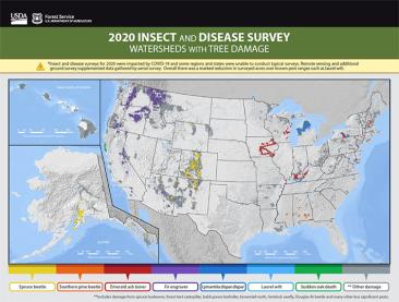
Detection surveys are the primary method of collecting Geospatial data on the health of treed areas affected by insects and disease and stored in a National Insect and Disease Survey (IDS) database. This process involves conducting annual aerial and ground surveys using the following systems:
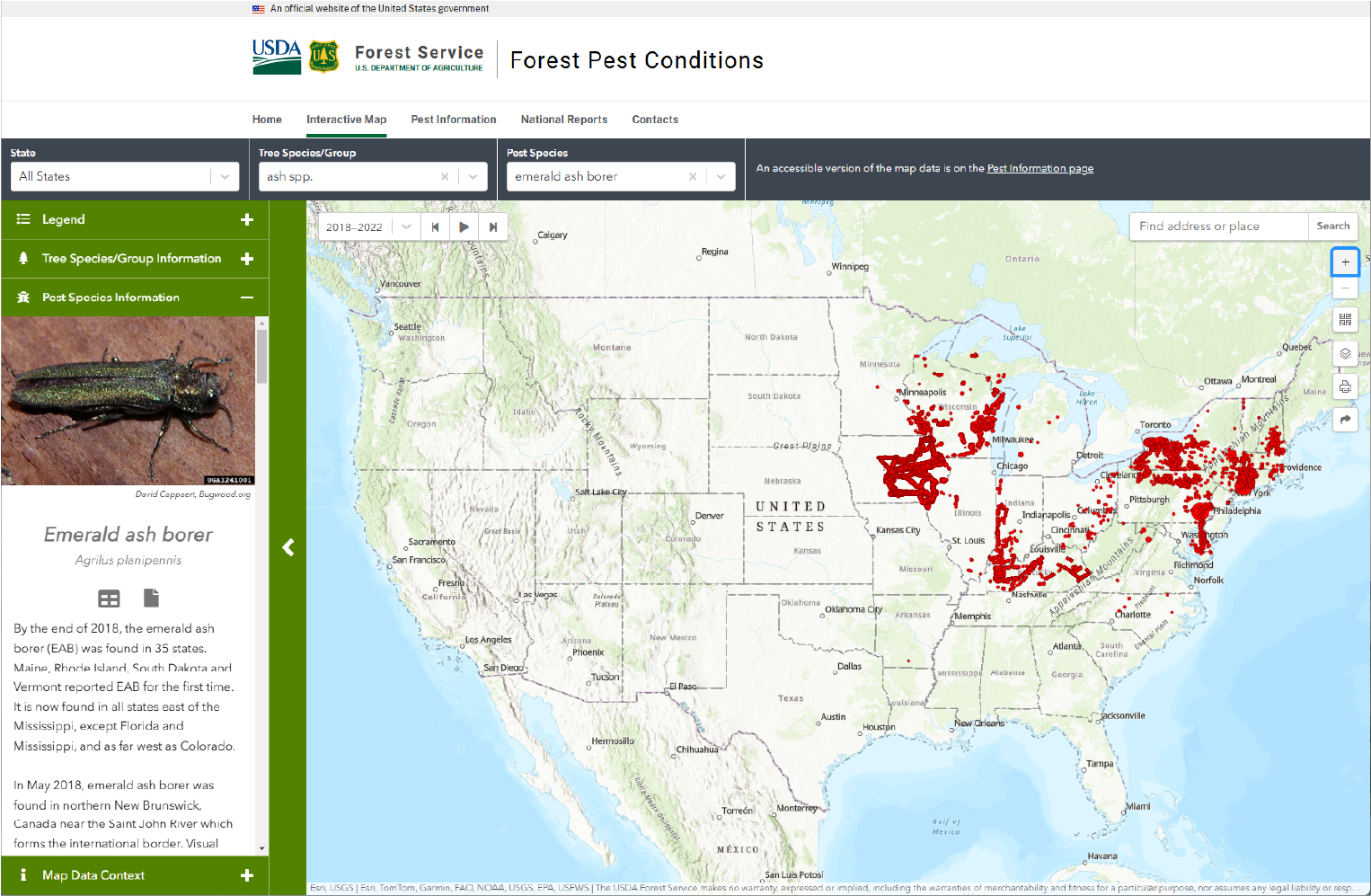
With the growing need to conduct complex spatial analysis and manage large datasets, the GIS and Spatial Analysis program has begun to develop applications to aid in data management and analysis. Examples of applications developed by FHAAST include:
FHAAST provides support for both tactical and strategic forest health risk assessments. In addition, this program coordinates, in collaboration with the USDA Forest Service Forest Health Monitoring program (FHM), the development of a National Insect and Disease Risk Map (NIDRM) and database.
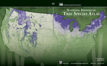
The Individual Tree Species Parameter Maps (ITSP) map basal area and stand density index for each individual tree species. The parameter products are based on 30-meter Landsat satellite data, climate, terrain, and soil predictor layers and ground samples from the USFS Forest Inventory and Analysis plot data.
The maps are an integration of various sources, reviewed by regional authorities. They are intended to display the biological extent of major damage agents, or the range over which they have been a managerial concern.
The Soil Drainage and Productivity Indexes provide information on the Drainage Index (DI) and Productivity Index (PI) of all soils that are classified within the US system of Soil Taxonomy. These data aid in the identification of areas at risk to various forest insects and diseases because of their ability to identify regions of potential tree stress.
The SPB Prevention and Restoration Program, along with local and regional resource managers, use the maps in planning activities and also to prioritize where prevention and restoration treatments should occur on the landscape to get the most cost-effective treatments.
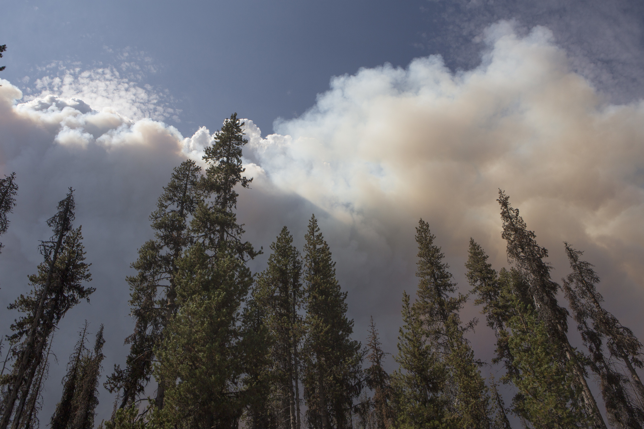
When we see a wildfire, our first response is to put it out. For decades, the Forest Service has done just that when it came to wildland fires. But science has changed the way we think about wildland fire and the way we manage it. We still suppress fires, especially if they threaten people and communities, but we understand that fire has a role in nature – one that can lead to healthy ecosystems. So we look for ways to manage it to play its role, for instance, by igniting prescribed fires.

The Forest Service conducts cutting-edge research and develops tools to help land managers better understand and manage fire. Our scientists study fire behavior and the effects of fire on ecosystems and society, as well as offer management options.
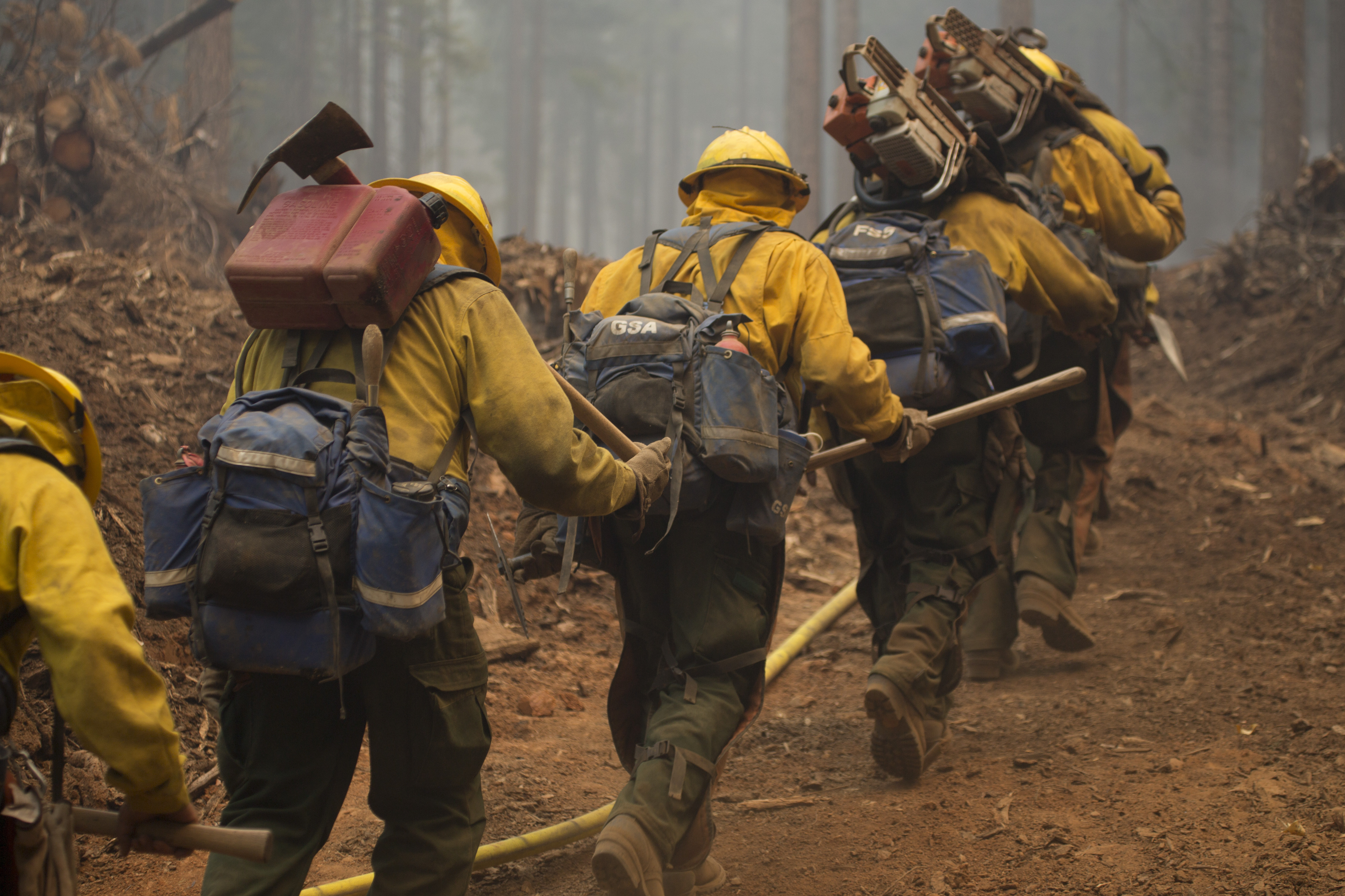
More than 73,000 wildfires burn an average of about 7 million acres of private, state and federal land in the U.S. each year. Forest Service firefighters respond to a significant number of those, either because they are burning on National Forest System land or because they are providing assistance to another federal, tribal, state or local partner.
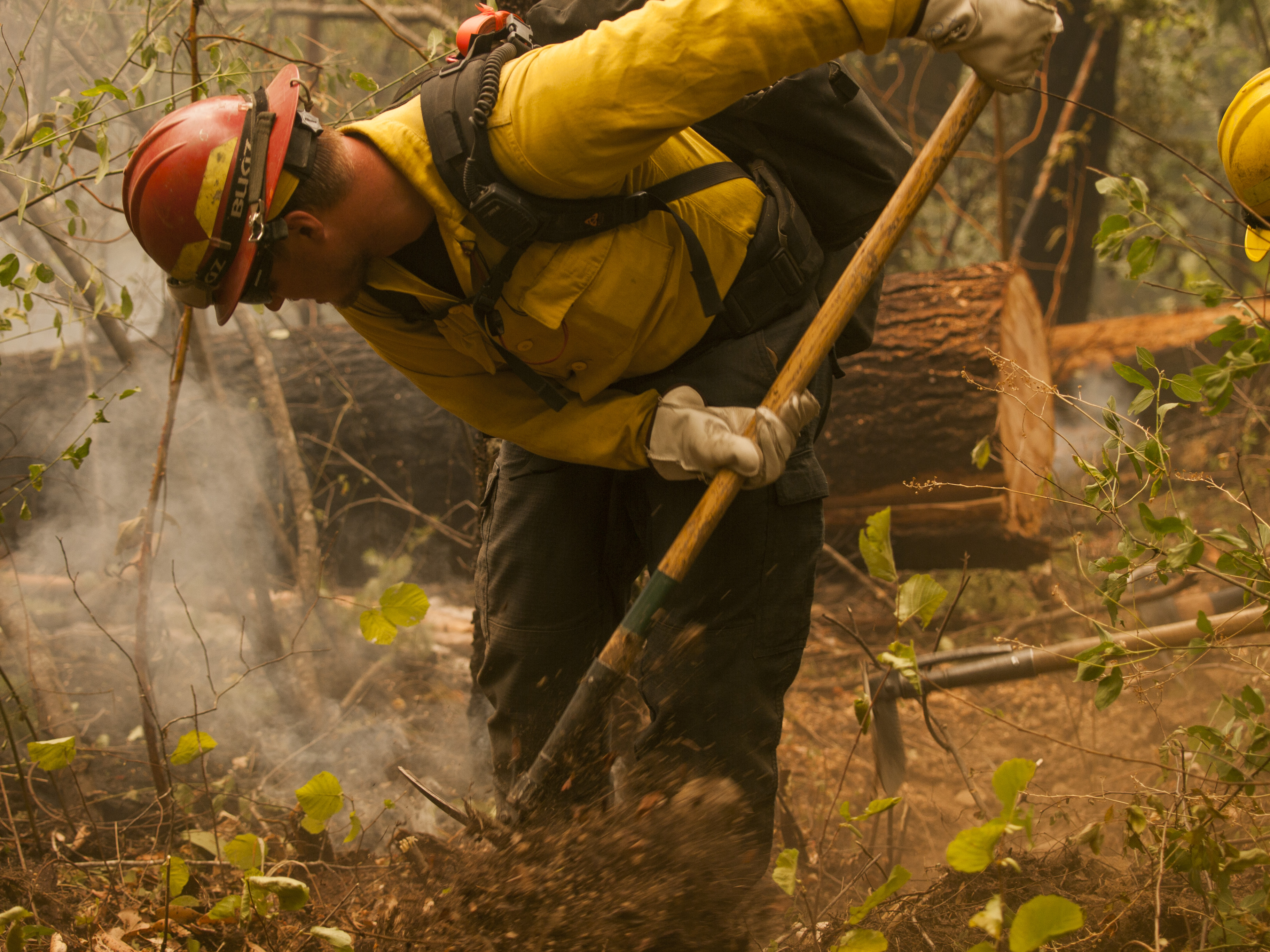
We need to be prepared with highly trained people, well designed tools and high performing equipment to respond safely and effectively to forest and grassland fires. Responding to fires often requires a mix of ground firefighters and aerial firefighting
Predictive Services provides information about fire weather, fire danger/fuels, and intelligence/resource status information that fire managers need to anticipate significant wildfire activity and determine where to poisiton firefighters, engines, aircraft and other wildfire suppression assets to respond to it.

National Predictive Services products include weekly and monthly significant wildland fire potential outlooks, intelligence reports that are produced daily or weekly depending on wildfire activity, and annual reports.
Detection surveys are the primary method of collecting Geospatial data on the health of treed areas affected by insects and disease and stored in a National Insect and Disease Survey (IDS) database. This process involves conducting annual aerial and ground surveys using the following systems:
With the growing need to conduct complex spatial analysis and manage large datasets, the GIS and Spatial Analysis program has begun to develop applications to aid in data management and analysis. Examples of applications developed by FHAAST include:
FHAAST provides support for both tactical and strategic forest health risk assessments. In addition, this program coordinates, in collaboration with the USDA Forest Service Forest Health Monitoring program (FHM), the development of a National Insect and Disease Risk Map (NIDRM) and database.
The Individual Tree Species Parameter Maps (ITSP) map basal area and stand density index for each individual tree species. The parameter products are based on 30-meter Landsat satellite data, climate, terrain, and soil predictor layers and ground samples from the USFS Forest Inventory and Analysis plot data.
The maps are an integration of various sources, reviewed by regional authorities. They are intended to display the biological extent of major damage agents, or the range over which they have been a managerial concern.
The Soil Drainage and Productivity Indexes provide information on the Drainage Index (DI) and Productivity Index (PI) of all soils that are classified within the US system of Soil Taxonomy. These data aid in the identification of areas at risk to various forest insects and diseases because of their ability to identify regions of potential tree stress.
The SPB Prevention and Restoration Program, along with local and regional resource managers, use the maps in planning activities and also to prioritize where prevention and restoration treatments should occur on the landscape to get the most cost-effective treatments.
When we see a wildfire, our first response is to put it out. For decades, the Forest Service has done just that when it came to wildland fires. But science has changed the way we think about wildland fire and the way we manage it. We still suppress fires, especially if they threaten people and communities, but we understand that fire has a role in nature – one that can lead to healthy ecosystems. So we look for ways to manage it to play its role, for instance, by igniting prescribed fires.

The Forest Service conducts cutting-edge research and develops tools to help land managers better understand and manage fire. Our scientists study fire behavior and the effects of fire on ecosystems and society, as well as offer management options.
More than 73,000 wildfires burn an average of about 7 million acres of private, state and federal land in the U.S. each year.  Forest Service firefighters respond to a significant number of those, either because they are burning on National Forest System land or because they are providing assistance to another federal, tribal, state or local partner.

We need to be prepared with highly trained people, well designed tools and high performing equipment to respond safely and effectively to forest and grassland fires.  Responding to fires often requires a mix of ground firefighters and aerial firefighting
Predictive Services provides information about fire weather, fire danger/fuels, and intelligence/resource status information that fire managers need to anticipate significant wildfire activity and determine where to poisiton firefighters, engines, aircraft and other wildfire suppression assets to respond to it.

National Predictive Services products include weekly and monthly significant wildland fire potential outlooks, intelligence reports that are produced daily or weekly depending on wildfire activity, and annual reports.


